Untitled Document


Concrete and Soil Imaging
for Forensic Engineering
 

Untitled Document
Home Page
SERVICES
Ground Penetrating Radar
Surface Penetrating Radar
Soil Mapping
Digital Scan Analysis
CUSTOMERS
Engineers
Architects
Construction
Contractors
Academic & Universities
Hospitals & Health Care
Municipalities / Government
Golf Courses
Agricultural
Cemeteries
ABOUT PEGASUS EC

Company Information


Untitled Document

Cage Code: 4H6E8

NAICS Codes & Classifications (NAICS)

541360 Geophysical Surveying and Mapping Services
541380 Testing Laboratories
541420 Industrial Design Services
541620 Environmental Consulting Services
541710 Research/Development in Physical, Engineering & Life Sciences

Standard Industrial Classification (SIC)

8731 Commercial Physical Research
8734 Testing Laboratories

Product Service Codes (PSC)

AA10 R&D - Insect & Disease Control
B510 Study/Environmental Assessment
F018 Other Range/Forest Improvements
F021 Site Preparation
R510 Study/Environmental Assessment
T009 Photographic - Aerial
T099 Other Photo Mapping Printing
Y211 Construct/ Dams
Y215 Construct/ Surface Mine Reclamation
Y300 Construct/ Restoration

Capabilities:

  • Vegetative Assessment
  • Utility Locating
  • Concrete integrity
  • Pavement integrity
  • Soil Mapping
  • Geological Survey
  • Soil 3-Dimensional Profiles


Untitled Document
Pegasus Environmental GPR images

Sub-Surface Investigation

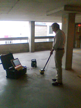
Surface-Penetrating Radar (SPR) is actually a more accurate title for Pegasus Environmental's services. Often, our builders and contractors require analysis through ceilings, walls, vertical structures or uneven surfaces such as rock or fabricated materials. SPR uses pulses of electromagnetic waves in the same manner as GPR. Our equipment is compact and versatile enough to provide substrait mapping images for a variety of surfaces.

Pegasus Environmental utilizes SPR to detect steel rebar, HVAC ducts, utility conduits, PVC pipes, voids and plumbing configurations. Locating these structures before drilling can save money and time, in addition to being a major safety benefit.

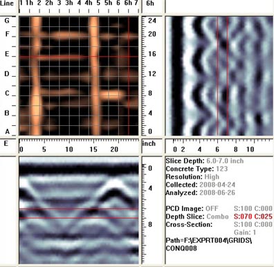
This image, processed at a dormitory at SUNY Brockport,
was taken through the roof of the building.
It indicates two levels of rebar several inches apart.
Near-exact depths can be attained for each, using Pegasus'
highly developed software and analysis capabilities.

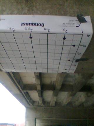
Surface penetrating radar can be used on ceilings to generate useful images, as well as on floor sufaces or the ground.

Uses for SPR

Surface Penetrating Radar can be used in building, construction, excavation, law enforcement, forensics, cemetaries, plumbing, carpentry or paving industries.

Any questions? Contact Pegasus Environmental, and we will eagerly respond to your general or specific questions.

Pegasus Environmental Co., P.O. Box 4, Spencerport, N.Y. (585) 278-0103
Powered By: Gleason PR